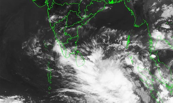
Cyclone Fani likely to transform into 'severe' storm in next 24 hours

Cyclone Fani, which has been forming in south-east Bay of Bengal and the adjoining Indian Ocean, is set to intensify into a severe cyclonic storm by this afternoon, according to the weather department. Currently, Cyclone Fani is moving in a north-west direction, centred at 1110 kilometres south-east of Chennai and 1300 km away from Machilipattinam.
Many places in Kerala are expected to get light to moderate rain on Monday and Tuesday, with heavy rainfall at a few places. North coastal Tamil Nadu and coastal Andhra Pradesh are set to get light to moderate rain at a few places on Tuesday and Wednesday.
In a press release on Saturday, the Indian Meteorological department said, "Cyclone Fani is very likely to intensify into a severe cyclonic storm during next 12 hours and into a very severe cyclonic storm during subsequent 24 hours."
The latest weather bulletin issued by Indian Meteorology Department says it was found laying centred at 1,110 km south-east of Chennai and 1,300 km away from Machilipattinam in the wee hours today. Under the category of Very Severe Cyclonic storm, Fani is expected to reach the state at a speed of 140-150 kmph on Tuesday. IMD also said, "It is very likely to move northwestwards till 30th April and thereafter recurve northeastwards gradually." North coastal Tamil Nadu and coastal Andhra Pradesh are set to get light to moderate rain at a few places on Tuesday and Wednesday. S. Balachandran, Director, Area Cyclone Warning Centre in Chennai, said 'Fani' was likely to intensify into a severe cyclonic storm in the next 24 hours.
The storm has been named 'Fani,' as suggested by Bangladesh, he said. Heavy falls at isolated places are very likely over Kerala on April 29 and 30. The sea along the coasts of Sri Lanka, Tamil Nadu and Andhra Pradesh is likely to be "very rough" from April 28, the IMD said. It has advised fishermen along the coasts of Sri Lanka, Tamil Nadu, Andhra Pradesh and Puducherry not to venture into the seas.
